2008 Survey & Monitoring – Eastern Oregon and Washington
Project: Whitebark Pine Survey and Monitoring – Eastern Oregon and Washington
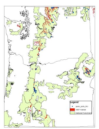
Agency/Forest or Park/District: Deschutes, Fremont-Winema, Malheur, Colville, Wenatchee, and Okanogan National Forests in central and eastern Oregon and Washington
Project coordinators: Chris Jensen and Kristen Chadwick
Contact
Chris Jensen, Genetics, Deschutes and Ochoco NF Bend/Ft.Rock Ranger District, 1230 NE 3rd St. Bend, Oregon 97701. 541-383-4779, cejensen@fs.fed.us
Kristen Chadwick, Forest Pathologist, Forest Health Protection, Deschutes NF, 541-383-5587. klchadwick@fs.fed.us
Cooperators
Deschutes National Forest
Lia Spiegel, Blue Mtn Pest Management Service Center, FHP, 541-962-6574, lspiegel@fs.fed.us
Connie Mehmel, Wenatchee Service Center, FHP 509-664-9213, cmehmel@fs.fed.us.
The Confederated Tribes of Warm Springs cooperated in the project by granting permission to survey on Tribal lands.
Source of funding
FHP: $23,000
Supplemental funding: $24,500 Deschutes NF and cooperators salary in kind, Central Oregon FHP.
Dates of restoration efforts
Summer 2008, 2009
Objectives
The objective of establishing these permanent plots is to determine the current forest health condition of whitebark pine and monitor the impacts of blister rust over time. Specifically, the plots will determine the presence and extent of blister rust, estimate mountain pine beetle activity, conifer encroachment conditions on sites, and current whitebark regeneration presence. These permanent plots will provide critical information currently lacking in many stands in eastern Oregon and Washington.
Methods
The survey and installation of permanent plots will be in accordance with the whitebark pine survey and monitoring protocol developed by the Whitebark Pine Ecosystem Foundation, revised in March of 2005 using the statistical releve approach of plots located in representative portions of the sample stand. Belt transect plots will be used for installing one belt line transect plot per PIAL habitat stand across the Forests.
Whitebark pine stands on the eastern slopes of the Cascades will be randomly selected for plot establishment. Plot locations will also be randomly placed within the stands and will be located away from trails and roads. For unique stands that occupy butte tops and are relatively small in size, such as on Black Butte on Sisters Ranger District, plot locations will also be randomly located. Due to recreation visitation, plots locations will be limited to keep visibility away from the recreating public.
All live whitebark pines above 1.4m tall will be tagged. Both plot level data and individual tree data collection methods will be done following the Whitebark Pine Ecosystem Foundation monitoring protocol. The following data will be collected on all live trees: tree status, dbh, stem cankers (active, inactive, uncertain, none, and other), branch cankers, canopy top kill, presence of bark stripping, and presence/absence of mountain pine beetle. For dead trees the following data will be collected: cause of death (blister rust, mountain pine beetle, fire, other/unknown), recent kill or snag. For whitebark pine <1.4m in height tree will be tallied by tree status (live without cankers, live with active cankers, live with inactive cankers, dead) and separated into height classes (trees < 50cm tall and >50 cm tall).
Planting? If so, source of seedlings? Resistance? No
Outcome
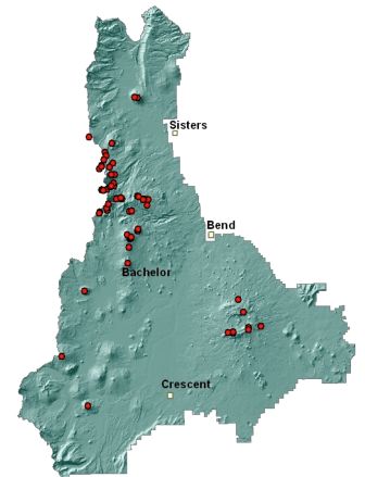
The project had a very successful start, with a total of 77 plots installed in the east slopes of the Central Oregon Cascades. Most these plots were established on the Deschutes NF with a few inside the boundaries of the Willamette NF and Mt. Hood NF (Mt. Jefferson Wilderness). Collectively, over 3000individual whitebark pine trees were accessed with 2163 live trees permanently tagged for future reference and monitoring.
The plots were installed using a FHP field crew, by Kristen Chadwick and Chris Jensen. Most of the Wilderness plots were established by WolfTree, INC employees, which is a local non-profit environmental outreach and education 501(c ) organization with a strong Forest Service partnership agreement.
The plot data was inputted into the Whitebark Pine Blister Rust Survey Access database version 1.01, and a suite of ArcMap coverages. An extensive series of plot photographs was also recorded. Additional data was collected on species other than WBP in each plot in an effort to broaden long-term effects and changes. As a result, the current Whitebark Pine Foundation’s blister rust database does not accommodate this additional data and a more comprehensive database was created and designed specifically for concerns in Oregon and Washington. With Kristen Chadwick (Forest Pathologist, Westside Oregon/Washington) as the Team Lead, this newly emerging database was funded by FHP outside the scope of this project, and is near completion and launching (2014). All the permanent plot data in R6 is targeted to reside in this database for safekeeping and to date has approximately 300 plots in it.
Acres/ha treated
A combined total of 77 plots were installed east slope habitats in central Oregon. Plots sizes were 150 feet x 30 feet with one to two plots per stand. Plots were located to sample the largest contiguous stands of whitebark pine representative of the local area.
Monitoring since completion of the project
No monitoring has occurred since plots were established in 2008 and 2009.
Plans for future monitoring?
Plots were established with a 5-7 year repeated monitoring regime in place. The plots are due for a follow-up visit, and funding channels are being pursued to re-monitor in 2014 or 2015.
Will outcome meet goals? Yes
Future actions/follow up?
A poster was generated summarizing the findings (attached) for information sharing and website posting. The findings and current conditions were presented by Kristen Chadwick at:
- July 2009 WIFDWC conference in Colorado,
- High-Five symposium in Missoula, Mt (2010).
- A future presentation is planned at a R6 WBP Working Group Restoration Planning meeting in March of 2014 (Portland, OR.)
Since this project was implemented, additional permanent plots have been installed in eastern Oregon, central and eastern Washington, and on the Winema and Fremont, the Mount Hood, the Gifford Pinchot National Forests. For a total of over 300. The Olympic National Park and National Forest is still lacking in the establishment of permanent plots.
Field methods have been refined over the last 7 years and most people are collecting data using the same standards and collecting data for all species.
Miscellaneous comments
Some modifications of the survey protocol have been implemented. The recording of blister rust cankers has been expanded to collect more quantitative and descriptive canker information which would assist in monitoring the intensification of canker growth and related tree damage and mortality.