2011 WBP Forest Inventory for BLM-administered land in Wyoming & Montana
Project: Whitebark Pine Forest Inventory for BLM administered land in Wyoming and Montana
Agency/Forest or Park/District: Dillon Field Office, Montana BLM, Kemmerer Field Office, Wyoming BLM

Project coordinator: Dana L. Perkins
Contact: Dana L. Perkins, Forest Ecologist and Five Needle Pine Coordinator, Idaho BLM, 1387 S. Vinnell Way,Boise, ID. 83709. Phone: 208-879-6243. Email: dana_perkins@blm.gov. Cell 208-481-1006
Cooperators
Robert Means, Forestry Lead, Wyoming BLM, William Hensley, Forestry Lead Montana, Joe Adamski, Forestry Lead, Idaho BLM, Emily Guiberson, Forester, Dillon Field Office, Jason Sieg, Forester, Kemmerer FO.
Source of funding /amount
FHP: $12,000
Supplemental funding: $8,460 Foresters oversight.
Dates of restoration efforts
July 2011-September 2014
Objectives
Our objective is to expand our forest inventory of lower treeline, whitebark pine woodlands on BLM administered lands to obtain estimates and causes of mortality, obtain white pine blister rust infestation levels, and obtain quantitative metrics on size and age structure. We initiated forest inventory in 2010 and obligated a contract for 2011 for four sites and 22 stands in Idaho. Our objective is to build on this inventory and expand to Montana and Wyoming. Funds would be used to augment the contract and/or add additional labor to season workforce.
Acres/ha treated
400-600 acres
Methods
Data collected shall be compatible with BLM’s Forest Vegetation Information System (FORVIS) version 3.0. Version 3 is a new (Nov. 2010) web based forest inventory program, with GIS capabilities. It complements, and can be used with USFS Common Stand Exam and Forest Vegetation Simulator (FVS).
Planting? If so, source of seedlings? Resistance? No
Outcome
Funding was obligated for a contract for forest inventory (stand exam) on approximately 1200 acres of BLM administered lands in 2011. Contractor completed inventory of 218 acres, on 6 stands, with 50 plots on Commissary Ridge on the Kemmerer Field Office (Fig. 1). Data was compiled in excel spread sheets and BLM’s Forest Inventory and Vegetation System (FORVIS). Remaining 8 areas, on approximately 1200 acres are slated to be completed summer 2014. Areas include Wyoming BLM Buffalo and Worland Field Offices, Montana BLM Dillon Field Office(Table 1).
Table 1. Stand areas, locations, size and number of plots slated for forest inventory for FY 2014.
| Area Information | Stand abbrev. | Forvis_id | ≈No. plots | ≈Stand size (acres) |
| Medicine Lodge (ML) | ML1 | DMDLG0670 | 10 | 45 |
| Quad: Medicine Lodge Peak, 1:24,000. | ML2 | DMDLG0740 | 10 | 55 |
| T 12 S, R 12 W, Sec(s) 15, 22 | ML3 | DMDLG0770 | 10 | 29 |
| Total Medicine | 30 | 129 | ||
| Upper Horse Prairie (UPH) | UHP1 | DUHPR1270 | 10 | 120 |
| Quad: Jeff Davis Peak, 1:24,000. | UHP2 | DUHPR1120 | 10 | 108 |
| T 11 S, R 13 W, Sec(s) 1, 2. | UHP3 | DUHPR1220 | 10 | 41 |
| UHP4 | DUHPR1210 | 10 | 26 | |
| UHP5 | DUHPR1180 | 10 | 70 | |
| UHP6 | DUHPR1190 | 10 | 31 | |
| Total Upper Horse | 60 | 396 | ||
| Widow Mountain (WM)Quad: Widow Mountain, 1:24,000T 43 N, R 4 E Sec. 22 | WM1 | IDCDWIDO001 | 10 | 63 |
| WM2 | IDCDWIDO002 | 10 | 23 | |
| WM3 | IDCDWIDO003 | 10 | 39 | |
| Total Widow Mountain | 30 | 125 | ||
| Rattlesnake Mountain (RM) | R3M1 | WYCOLOGA001 | 10 | 44 |
| 1:24,000 Quad: Logan Mountain | ||||
| T 53 N, R103W, Sec(s) 7. | ||||
| Total Rattlesnake | 10 | 44 | ||
| Grass Creek (GM)1:24,000 Quad: Milk Creek | GC1 | WYWOMINK001 | 10 | 90 |
| T 45 N, R 100 W, Sec(s) 17, 20 | ||||
| Total Grass Creek | 10 | 90 | ||
| Billy Creek (BC)1:24,000 Quads: Robinson Canyon, Klondike RanchAccess Billy Creek Rd. | BC1 | WYBUROBI001 | 10 | 80 |
| T48N, R83W, Sec(s) 19, 28, 29, 33, 34 | BC2 | WYBUROBI002 | 10 | 36 |
| Estimate Billy Creek | 20 | 116 | ||
| South Bighorns -Mayoworth Road (MR) | MR1 | WYBUFRAK001 | 10 | 14 |
| 1:24,000 Quads: Fraker Mountain, Packsaddle Canyon.Location: T45N, R84W, Sec(s) Sec(s) 6-8, 16, 17, 21, 22, 25-28 | MR2 | WYBUFRAK002 | 10 | 35 |
| MR3 | WYBUFRAK003 | 10 | 39 | |
| MR4 | WYBUFRAK004 | 10 | 24 | |
| MR5 | WYBUFRAK005 | 10 | 32 | |
| MR6 | WYBUFRAK006 | 10 | 59 | |
| Estimate Mayoworth | 50 | 203 | ||
| South Bighorns – Middle Fork (MF) | MF1 | WYBUGORD001 | 10 | 48 |
| 1:24,000 Quads: | MF2 | WYBUGORD002 | 10 | 29 |
| Poker Butte, Gordon Creek | ||||
| Location: | ||||
| T42N, R84W, Sec(s) 16-18, 19-21, 28-30 | ||||
| T42N, R85W, Sec(s) 35, 36 | ||||
| Access: Unimproved road to Middle Fork Recreation Area. Any other routes require permission from local landowners. | ||||
| Estimate Middle Fork | 20 | 77 | ||
| TOTAL FY2013-2014 | 230 | 1,180 |
Monitoring since completion of the project
Dates: 2012- Kemmerer FO used stand exam information for silvicultural
prescriptions to remove subalpine fir, the dominant competitor with whitebark and limber pines. (Figure 1) Whitebark pine composed 10-68% of species composition for trees greater than 4.5 feet in height, before thinning. Seventy five acres were treated in 2013 and 175 acres are slated for treatment in 2014. Contact is BLM forester Jason Sieg, jsieg@blm.gov, Kemmerer Field Office.
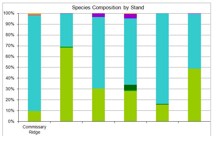
Figure 1. Commissary Ridge species composition (trees greater than 4.5 feet height) inventoried 2011.
Plans for future monitoring?
This is the southernmost stand of whitebark pine in the Rocky Mountains and we expect to monitor the success of thinning to favor whitebark and limber pines on this site. There are also 8 whitebark pines and 10 limber pine plus trees at this site.
Will outcome meet goals?
Yes. BLM’s FORVIS database has already been populated with stand data from Idaho. The completion of this contract in Wyoming and Montana will provide stand structure, species composition and disease and insect information to silviculturist and will be housed at the National Operations Center in Denver as well as at local field offices.