2013 WBP Health in the Bob Marshall Wilderness Complex
Project: Whitebark Pine Health in the Bob Marshall Wilderness Complex
Attachment: BobMarshall_Treadwell_2013_Map of WBP plots 2013
Agency/Forest or Park/District: Middle Fork of the Flathead, Dean Ridge, Sunburst Lake, Picture Ridge, Montana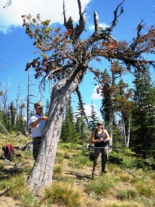
Project coordinator: Carol Treadwell
Contact: Carol Treadwell, PhD. Executive Director, Bob Marshall Wilderness Foundation, PO Box 190688, Hungry Horse, MT 59919. 406-387-3847. exec@bmwf.org
Ed Lieser, BMWF Board Director. 1355 Lion Mt. Dr., Whitefish, MT 59937. 406-471-2082. liesered@yahoo.com
Cooperators
Melissa Jenkins, Flathead National Forest, Forest Silviculturist will sponsor the BMWF and provide measurement equipment for the volunteers.
Bob Keane, USDA Forest Service, Rocky Mountain Research Station, Missoula Fire Sciences Laboratory
Source of funding /amount
FHP: $4,954
Supplemental funding: $3,710 from Missoula Fire Science Lab, BMWF and Spotted Bear Ranger District.
Dates of restoration efforts
Summer 2013
Objectives
Revisit tree plots measured in 1991 by Bob Keane and assess the status of whitebark pine in 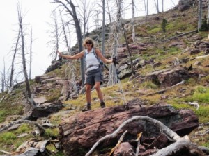 the Bob Marshall Wilderness to determine health, condition, and mortality
Acres/ha treated
12 plots, 0.1 acres in size in the areas mentioned
Methods
The Bob Marshall Wilderness Foundation (BMWF) engages volunteers in active wilderness stewardship. Using a Citizen Science approach, BMWF will recruit and engage 3 to 5 volunteers for two backcountry Whitebark pine data collection trips. The volunteers will be led by a BMWF crew leader and one trip will be accompanied by a member of Dr. Keane’s staff. The volunteers and crew will be trained for data collection by Dr. Keane’s staff to ensure quality and consistency with original data.
During two trips, 5 and 6 days in length, volunteer crews will revisit 10% (twelve) of the 112 plots measured in 1991. One trip would consist of day hikes in the Middle Fork of the Flathead valley and on Dean Ridge in the Hungry Horse and Spotted Bear Ranger Districts. A second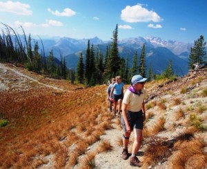 trip would involve backcountry travel to Sunburst Lake and Picture Ridge. Original plots will be relocated using a hand held GPS with UTM coordinates and the plot tree lists provided by Dr. Keane.
Plots in the study are circular in shape and 0.1 acre (0.04 ha) in size. Crews will measure the health, condition and mortality of whitebark pine following the protocol utilized in the 1991 study. For trees above 4.5 in. DBH species, DBH (tree diameter at breast height), tree height, height to crown base, and health (live, sick, dying, or dead) and the percent crown volume killed by blister rust is measured for all whitebark pine trees. The same characteristics are measured for all live trees less than 4.5 in. DBH and higher than 4.5 feet tall except DBH is estimated to 1 inch diameter classes. Tree seedlings (trees less than 4.5 feet) are counted by 1 foot height classes on a 1/100 acre circular plot in the middle of the tenth acre plot using the same plot center (Keane, verbal comm.)
Planting? If so, source of seedlings? Resistance? No
Outcome
The Bob Marshall Wilderness Foundation (BMWF), with assistance from the Missoula Fire Sciences Laboratory, measured Thirteen (13) whitebark pine plots in the Bob Marshall Wilderness Complex. The plots were part of a study conducted by Robert Keane in 1991-94 which recorded rapid decline of WBP in the BMWC. BMWF crews revisited 10% of the original 112 plots (13 plots).
Using a Citizen Science approach, BMWF recruited volunteers for three backcountry Whitebark pine data collection trips. The volunteers were led by a BMWF crew leader and a forestry technician from Dr. Keane’s staff. The volunteers and crew were trained for data collection to ensure quality and consistency with original data.
Plots were remeasured at the following locations: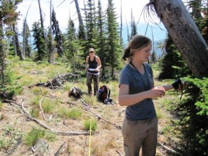
Green Mtn, Spotted Bear Ranger District (2 Plots)
Inspiration Pass, (1 plot)
Sunburst Lake, Spotted Bear Ranger District (2 plots)
Picture Ridge, Spotted Bear Ranger District (3 plots)
Ouzel Peak, Hungry Horse RD (2 plots)
Morrell Peak, Seeley Lake RD (3 plots)
Thirteen Total (See Attached Map)
Plots were relocated using GPS and photographs taken at the plot center during the 1991 study. The coordinates provided were in NAD27, (a datum used by GPS units in the ‘90s). These UTM’s were entered into a Garmin GPS which then converted to the WGS84 datum, (the datum in use today). Research crews then navigated to the plot centers using this GPS unit. Upon locating the closest navigable point, the crews narrowed the search using photographs taken by the 1991 research team. Ten (10) of the 13 were located within good certainty of being in the exact same location as the original. Three plots were of uncertain accuracy to the original location.
Whitebark pine were observed at 11 of the 13 plots as trees, seedlings, and saplings. Trees were affected by rust and beetle kill. A third dominant killer of WBP was fire. Four of the 13 plots were either partly or fully burned.
Preliminary analysis and evaluation of the collected data indicate several important findings. First, it appears wildland fire has burned several of the areas where plots were located causing additional whitebark pine mortality. This is expected and some of these burned sites have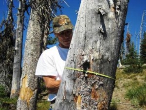 some new whitebark pine regeneration. Chances are that these seedlings are from the seeds of rust-resistant trees. Second, it appears that tree mortality from rust and beetles has caused further decline in the Bob Marshall Wilderness Complex. For some plots mortality by beetle kill was observed to be more prevalent while rust was noted to affect WBP in some plots but not others. The rate of mortality appears to have slowed significantly and we may have reached a somewhat stable population level. This is probably the result of several interacting factors including the fact that the populations were already quite low (>40% mortality), the lack of large whitebark pine trees due to past mortality (large trees are the first to be infected and killed by rust and beetles), and the remaining live trees being somewhat rust resistant. Further analyses of these data are critical to support these claims, but the number of plots that have been revisited is so low that any statistical analysis will have significant limitations. More data are needed to draw viable conclusions from this valuable plot remeasurement.
Monitoring since completion of the project
Dates: This project is a monitoring project. Monitoring took place on: 8/10-8/11/13, 8/24/13, 9/16 – 9/18/13.
Plans for future monitoring? If funded, monitoring will continue in 2014 with 12 to 15 more plots revisited from those originally measured in 1994.
Will outcome meet goals?
Yes. We have met the study objective to revisit and remeasure 10% of the plots in the original study (Keane, 1994). To date the data still needs to be analyzed digitally for tree, seedling, and sapling number, size, and health before a quantitative comparison of WBP present in 1991 vs. 2013 can be made.
Future actions/follow up?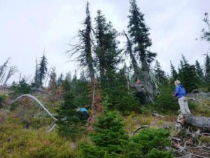
A technical report of the data is planned. However, the number of plots that have been revisited is so low that any statistical analyses will have significant limitations. More data are needed to draw viable conclusions from this valuable plot remeasurement
Miscellaneous comments
Due to the limitations of monumenting plots in the wilderness teams had to rely on digital UTM data and photographs from the ‘90s. This was surprisingly very successful for many of the plots but due to tree mortality and ingrowth, locating original plot centers was problematic for some plots. For example, Picture Ridge plot N2 was relocated within the accuracy of the GPS coordinates, but we could not find the precise plot center using the photos.