2007 Assessing WBP Regeneration in Disturbed Areas
Project: Assessing Whitebark Pine Regeneration in Disturbed Areas Attachment:WindRiverShoshone_Jacobi_2007_Report
Agency/Forest or Park/District: Wind River Reservation, Bridger-Teton and Shoshone National Forests, Colorado State University, Wyoming
Project coordinator: William R. Jacobi
Contact: William R. Jacobi- Dept. Bioagricultural Sciences and Pest Management, Colorado State University, Fort Collins, CO 80523-1177 970-491-6927 william.jacobi@colostate.edu
Cooperators: Wind River Reservation, Shoshone National Forest, Jim Blodgett, FHM, and Anna Schoettle Rocky Mountain Research Station.
Source of funding /amount
FHP: $34,486
Supplemental funding: $57,500 from FHM and CSU
Dates of restoration efforts
Summer 2007
Objectives
Determine regeneration success in non disturbed, recent burned (between 5-20 years) areas.
Acres/ha treated
N/A, this assessment covered the northern Wind River and southern Absaroka Mountain Ranges.
Methods
Regeneration plots will be established in burned areas of at least two ages, stands with recent (1-5 yr) and older (>5 yr) bark beetle caused mortality, and areas with at least 50% incidence of blister rust, and also undisturbed stands. A minimum of 80 plots will be established in these stands. Clusters of five circular fixed area subplots will be randomly located within stands that represent the disturbance types. Regeneration numbers, health, size of seedlings and residual stand or previous stand characteristics will be recorded. The micro habitat of each seedling will be recorded to build a data base on the proper treatments to promote seedling survival and the survival of planted seedlings.
Planting? If so, source of seedlings? Resistance? No
Outcome
Field work was conducted in 2007 from late July to late September. A total of six fires were sampled with permanent regeneration monitoring plots that were established in non-burned forested areas, forested areas burned 8 to 15 years previous, and areas burned 16 to 32 years previous (Table 1). Fires ranged in elevation from 2670 to 2890 m and their sizes varied (12 to >2000 ha) with three fires encompassing large areas over 1000 ha each (Table 1). Sampled fires were in areas of potential whitebark pine habitat as defined by elevation and surrounding vegetation, and within an hour hike from a road.
In each burn area, sites with similar aspects, elevation and forest types were delimited using GIS. The number of sites within a burned area depended on the uniformity of the burn area in regard to aspect, elevation, forest type and size of the fire. Sample sites in the non-burned areas were selected from the surrounding forest to match the aspect, elevation and forest type and number of the burned sites. In large burn areas up to four sites were identified for sampling to ensure an adequate representation of the conditions within the burn area. Sample sites range in size from 12 to 20 ha (Table 1). Within all the sites, a total of 74 transects were sampled in the burned areas and 28 in the non-burned areas. Transects were 2 m in width and a minimum of 200 m in length. On the transects, a total of 256 plots in burned areas and 140 plots in non-burned areas were established, in which regeneration were tallied (Table 1, Figure 1). All individual trees were tallied by species in each plot within five height classes (< 20 cm, 20-99.9 cm, 100-199.9 cm, 200-300 cm, ≥300 cm). Microsites within 20 cm around whitebark pine regeneration were classified as: open, no protection from wind or solar; near the base of a tree or under low tree canopy; near downed woody debris, logs, or roots; rocks; and in cracks or holes in trees. To assess the nearest whitebark pine seed source, variable radius plots within the non-burned perimeter of the fire were established 80 m in distance from each.
Table 1. Fires sampled and average density of live whitebark pine in the northern Wind River and southern Absaroka Mountain Ranges, WY.
| Shoshone NF/ Washakie District | Bridger-Teton NF/ Jackson District | Wind River Reservation | ||||||
| Fire name | Geyser Creek | Unit 40 | Moccasin Basin | Dry Cottonwood | Willow Creek | Crow Creek | ||
| Fire year | 1975 | 1988 | 1999 | 1991 | 1988 | 1994 | ||
| Area burned (ha) | 114 | 556 | 12 | 2411 | NA | NA | ||
| Average elevation (m) | 2762 | 2670 | 2764 | 2872 | 2926 | 2799 | ||
| Number of sites1 | 2 | 4 | 1 | 4 | 1 | 2 | ||
| North facing | 1 | 4 | 0 | 2 | 1 | 1 | ||
| South facing | 1 | 0 | 1 | 2 | 0 | 1 | ||
| Number of plots in burned area | 48 | 76 | 16 | 65 | 15 | 36 | ||
| Number of plots in non-burned area | 20 | 40 | 10 | 40 | 10 | 20 | ||
| Average number/ha of live whitebark pine < 1 m in height | ||||||||
| Burned (SE) | 612 (109) | 854 (116) | 8 (8) | 1085 (236) | 867 (276) | 97 (39) | ||
| Un-burned (SE) | 1238 (260) | 834 (237) | 238 (78) | 1950 (335) | 213 (79) | 725 (141) | ||
| Whitebark pine (all sizes) with white pine blíster rust (WPBR) | ||||||||
| % live WB stems ha-1 with WPBR | 3.5 | 10.7 | 0.0 | 3.9 | 4.2 | 2.6 | ||
| Whtebark pine (diameter at breast height > 20 cm) attacked by mountain pine beetle (MPB) 2 | ||||||||
| Post-fire MPB killed WB stems (%) 2 | 22.5 | 51.5 | 42.5 | 37.1 | 17.1 | 1.4 | ||
| Pre-fire MPB killed WB stems (%) 2 | 18.8 | 2.6 | 0.0 | 9.7 | 22.3 | 0.2 | ||
1 Sites are defined as being made up of a burned and non-burned area that have similar aspects, elevations, and forest types.
2 MPB attacked trees in non-burned area.
The incidence of white pine blister rust (WPBR) in our study area was generally low, while the incidence mountain pine beetle attacks were generally high with greater than 50% of susceptible trees being infested in some fires (Table 1). The incidence of WPBR on regeneration within burns was low (< 1%) and did not appear to threaten regeneration density in burned areas, while the incidence of WPBR on taller regeneration in the non-burned stands was higher (2%).
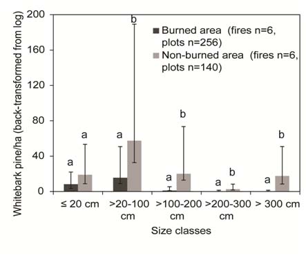
Whitebark pine regeneration densities in burned and non-burned areas were variable, with more than 25% of the plots lacking whitebark pine presence. Whitebark pine regeneration densities, in every height class except ≤ 20 cm seedlings, were significantly lower in burned areas than in non-burned areas (Fig. 1).
Figure 1. Adjusted mean density of live whitebark pine regeneration (back-transformed from log10) in burned and non-burned areas (adjusting for aspect) in the northern Wind River and southern Absaroka Mountain Ranges, WY. Trees potentially planted in the Geyser Creek and Unit 40 firs are not included. Error bars are Half Fisher’s least squared differences. Different letters within size class denote significant difference at p<0.05. Note: height class does not equate to age of tree.
 The density of whitebark pine in burned areas was greater on north aspects compared to south aspects for the two shortest height classes (≤ 20 and >20-100 cm). There were 12 times more whitebark pine ≤100 cm on north facing slopes as compared to south facing slopes in burned areas (p<0.05).
Positive covariates in the models for the height classes ≤ 100 cm in height in burned areas were: basal area of nearest whitebark pine potential seed source, percent cover of shrubs, number of years since the fire, and density of lodgepole pine (seedlings to mature trees). Percent cover of grass and minimum distance to potential whitebark pine seed source were negative covariates. Mature or cone-bearing trees were considered potential seed sources. Average minimum distances from plots in burned areas to potential seed source ranged from 90 to 383 m. The basal area of mature, live whitebark pine adjacent to burns ranged from 3.2 to 7.0 m2 ha-1.
A large proportion of whitebark pine seedlings <100 cm in height in both burned and non-burned areas occurred in microsites with downed woody debris, logs and roots (Table 2). High percentages of whitebark pine regeneration in burned areas (81%) and in non-burned areas (48% total, 46% under protection of low canopies or bases of trees) were found in microsites created by trees, downed woody debris, logs, and roots. In the burned areas, there was less proportion of whitebark pine regeneration under the protection of tree bases or under low tree canopies compared to non-burned areas, which was likely related to the lack of canopy cover in burned areas. All other microsites categories had equal density of whitebark pine regeneration in burned and non-burned areas.
Table 2. Percent of live whitebark pine regeneration ≤ 100 cm in height and mean density (back-transformed from log10) by microsite location in the northern Wind River and southern Absaroka Mountain Ranges, WY. Trees potentially planted in the Geyser Creek and Unit 40 fires are not included. Values are adjusted for aspect.
| Burned area(n=256 plots) | Non-burned area(n=140 plots) | ||||
| Microsite type 1 | % stems | stems ha-1 (± half LSD) | % stems | stems ha-1 (± half LSD) | p-value |
| Base of trees or tree canopy± half LSD | 4.7 | 0.7(0.2, 1.6) | 46.5 | 18.7(13.1, 28.7) | 0.001 |
| Downed woody debris/logs± half LSD | 81.2 | 12.1(6.7, 21.2) | 48.3 | 19.4(10.8, 34.3) | 0.439 |
| Open, no protection± half LSD | 10.1 | 1.5(0.6, 3.0) | 4.2 | 1.7(0.6, 3.4) | 0.892 |
| Rocks± half LSD | 3.3 | 0.5(0.2, 0.8) | 1.0 | 0.4(0.2, 0.7) | 0.813 |
1 Microsite type: object was within 0.2 m of the seedling
Note: Fisher’s least squared differences is abbreviated by LSD.
Monitoring since completion of the project
Dates: No monitoring has occurred
Plans for future monitoring?: There are potential plans to monitor these sites by the local forest ecologist.
Will outcome meet goals? We did determine the regeneration in fires compared to unburned forests.
Future actions/follow up? A monitoring of these plots would be very useful in about 2017 to see if our findings are still correct for these fires.
Miscellaneous comments
The fires that were available to sample in the Shoshone and Bridger-Teton NF and Wind River Reservation were relatively low in elevation and sometimes had a component of limber pine in the lower elevations. Therefore, regeneration could either be whitebark pine or limber pine because the Clark’s nutcracker flies many kilometers to cache seeds of both species of white pine. The last few years were poor cone crops for both white pine species and our field season was past the time when male cones are present, making it difficult even to identify to species adult trees.